|
|||
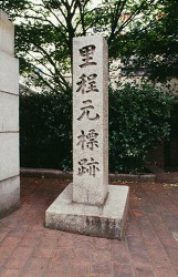
| Å@ | Eastend of Koraibashi, Chuo-ku | ||
| Åm Kitahama Ån by Sakaisuji and Keihan Line
about 350m to the southeast |
| In the Edo era, people measured the
distance of all the roads with the eastend
of Koraibashi as the starting point. Kyokaido, Chugokukaido and Kishukaido started here and a fare was measured too from here. After the national road system was set in the force in the 9th year of Meiji, Koraibashi remained as a starting point and city road terminal point was set up at the south east end of the bridge but later was settled at the south west corner of the Umedashinmichi cross road. From the Edo era, Koraibashi was regarded as important among official bridges and the place of official notice of the shogunate was set up at the west end of the bridge. In addition, Koraibashi was the first iron bridge in Osaka(the 3rd year of Meiji). Å@ |
|
 |
| to the top of The Uemachi-daichi kita course |