 It
is said that this river was created in 1698, at the time the development
of the new rice fields in Tsumori commenced, by Zuiken Kawamura. At the
time, it ran from the Nanase River, which flowed along Tsumori's northern
boundary with Naniwa-ku, to Nakazaike Village (now Kohama in Suminoe-ku)
and took on water from the Kizu River as it wended its way south. However,
in 1704, when the river was extended to reach the Yamato River due to
the renovation of the latter, the Jusangenbori River was inundated with
soil and sand; the riverbed at the southern end began to rise, and the
river began to flow north. It
is said that this river was created in 1698, at the time the development
of the new rice fields in Tsumori commenced, by Zuiken Kawamura. At the
time, it ran from the Nanase River, which flowed along Tsumori's northern
boundary with Naniwa-ku, to Nakazaike Village (now Kohama in Suminoe-ku)
and took on water from the Kizu River as it wended its way south. However,
in 1704, when the river was extended to reach the Yamato River due to
the renovation of the latter, the Jusangenbori River was inundated with
soil and sand; the riverbed at the southern end began to rise, and the
river began to flow north. 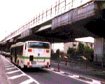 The
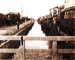
river was used for agricultural irrigation up until the early Meiji period,
however the river and its pine and willow-lined banks provided a wonderful
attraction for the area, bringing people from Osaka to Sumiyoshi. These
days, most of the river has been reclaimed, and as the river was in the
way of the Hanshin Expressway to Sakai in February 1970, much of it was
lost, meaning there are only a few traces of it left, and those are in
Suminoe-ku. The
river was used for agricultural irrigation up until the early Meiji period,
however the river and its pine and willow-lined banks provided a wonderful
attraction for the area, bringing people from Osaka to Sumiyoshi. These
days, most of the river has been reclaimed, and as the river was in the
way of the Hanshin Expressway to Sakai in February 1970, much of it was
lost, meaning there are only a few traces of it left, and those are in
Suminoe-ku.
(From the records of the Tsumori Historical Society) |
