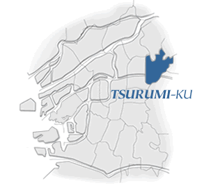
Tsurumi-ku was separated from
Joto-ku on July 22, 1974, by the reorganization of administrative
sections.
The district is located at the easternmost side of Osaka City,
and is adjacent to Joto-ku and Asahi-ku, as well as Moriguchi,
Kadoma, Higashiosaka and Daito Cities.
The district has many rivers and waterways. The Neyagawa River crosses east-west through the district, while the Nishisanso Storm Drain and Furu River flow through the district from north to south, later merging with the Neyagawa River. In the eastern end of the district is an old canal referred to as an iji (literally a well and irrigation canal).
The district is crossed by the following trunk lines: Shinjo-Yamatogawa
Route, Yakeno-Nakachaya Route and Expressway Chuo Loop Line from
north to south; Miyakojima-Matta Route (Hanahaku Road), Higashinoda-Matta
Route (Tsurumi Road), and Katamachi-Tokuan Route from east to
west. The Subway Nagahori-Tsurumiryokuchi Line runs through the
center of Tsurumi-ku, while JR Gakkentoshi Line (Katamachi Line)
connects the east and west sides of the district in its southern
part.
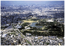
In the northern part of Tsurumi-ku is one of the largest urban
parks in Osaka Prefecture. The Flower Expo Memorial Park (Tsurumi
Ryokuchi Park) has many facilities ranging from a pool, athletic
ground, baseball park, barbecue field, horse-riding field and
a park golf ground, to Sakuya Botanical Dome, Earth Environmental
Museum and Nature Garden. The facilities and the park are very
popular among citizens and visitors, providing good times for
relaxation, learning and exchange in a rich natural environment.
Since the flower expo at Tsurumi Ryokuchi, public transportation
has become dramatically more convenient with the extension of
Subway Nagahori-Tsurumiryokuchi Line and completion of JR Tozai
Line. The population is expanding remarkably as the residential
environment improves through these changes, as well as construction
and renovation of public and private housing, widening of Higashinoda-Matta
Route (Tsurumi Road), etc.
Also, the area is being developed to activate Tsurumi-ku, which includes the opening of a citizen center, the opening of the JR Osaka Higashi Line, the construction of a large shopping center on the former site of a large company and the construction of large apartment buildings.
Once development around Hanaten Station is completed, the district will improve by having a safe transportation environment. Tsurumi-ku is expected to grow as the eastern end of the east-west expansion of Osaka as an international tourist city and one of the few urban areas in good harmony with the natural environment.
|