Earthquakes in Osaka
EARTHQUAKES - 2 Types of Earthquakes
Interplate Earthquakes (Trench Type)
The surface of the globe is covered with a rock base called a "plate" which is approximately several tens to several hundreds of kilometers in thickness.
Around the Japanese Archipelago there are 4 plates: the North American Plate, the Eurasian Plate, the Philippine Sea Plate, and the Pacific Plate. They move in different directions at a speed of several centimeters per year.
Distortion energy accumulates along the plate boundaries and when the accumulation of this energy reaches its limit, the plate boundaries suddenly rebound back to their original states, and an interplate earthquake occurs.
Interplate Earthquakes (Inland Type)
The energy that has been accumulated by the mutual movement of plates is not consumed completely along the plate boundaries. This energy also generates deformation in plates leading to the formation of faults. When such a fault is dislocated rapidly, this type of earthquake occurs.
ACTIVE FAULTS
Cracks are created in the earth's crust and the ground on both sides of these cracks move in opposite directions.
When this occurs, this formation is called a "fault." A fault which was created or moved a million years ago and is likely to be active in the future is geologically called an "active fault."
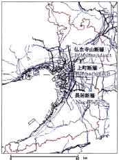
According to the results of a survey by Osaka City, the location of the Uemachi Fault Group is assumed to be as shown in the drawing.
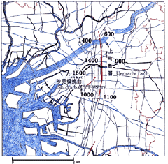
(depth of sedimentary layer:m)
|
 |
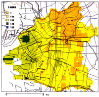
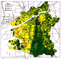
Hypothesized Earthquake Damage
Distribution of Seismic Intensities
In the area around the outer periphery of Osaka City and the city itself, there is the Uemachi Fault Group consisting of the Butsunenjiyama Fault, Uemachi Fault and Nagai Fault; each fault is considered to be connected. The drawing below shows an example of the largest conceivable earthquake on the assumption that there is an epicenter at the southern end of the Uemachi Fault and the motion of the fault spreads in a north-south direction.
LIQUEFACTION PHENOMENON
When a sand layer that maintains a uniformly saturated balance beneath the groundwater level is shaken by a strong earthquake, the sand layer tries to push water out of the interstices between the sand grains. Finally, the sand grains will be disengaged and enter a state where the sand grains float in water, and the resulting gush of water will pour out together with the sand grains to the surface.
|